Randonnée Marche Gemeinde Natters - Natterer See Camping vers Innsbruck AR - Photo

Natterer See Camping vers Innsbruck AR

 Maca8284
Maca8284

Utilisateur

© OpenStreetMap contributors
Longueur
Longueur
18,3 km
Altitude max
Altitude max
875 m
Dénivelé positif
Dénivelé positif
461 m
Km-Effort
Km-Effort  
25 km
Altitude min
Altitude min
574 m
Dénivelé négatif
Dénivelé négatif
509 m
Boucle
Boucle
Non
Date de création :
2019-11-07 08:33:18.523
Dernière modification :
2019-11-07 15:28:40.046

(0 Avis)

Marche
Marche
5h43
Difficulté : Facile

Scannez ce code QR pour ouvrir la randonnée dans l'application SityTrail

Application GPS de randonnée GRATUITE

Logo SityTrail SityTrail

IGN / Instituts géographiques

Télécharger SityTrail sur l'App Store Télécharger SityTrail sur Google Play

Logo SityTrail SityTrail World

Le monde est à vous

Télécharger SityTrail sur l'App Store Télécharger SityTrail sur Google Play Télécharger SityTrail sur Huawei AppGallery

À propos

Randonnée Marche de 18,3 km à découvrir à Tyrol, Bezirk Innsbruck-Land, Gemeinde Natters. Cette randonnée est proposée par Maca8284.

Description

Super rando pour la 2ème fois!

Profil altimétrique

Localisation

Pays :
Autriche
Région :
Tyrol
Département/Province :
Bezirk Innsbruck-Land
Commune :
Gemeinde Natters
Localité :
Unknown
Départ:(UTM)
677876 ; 5234411 (32T) N.

Randonnées à proximité

Randonnée A pied Inconnu - Stangensteig-Trail - Photo
A pied
PRO

A pied

Facile
Inconnu, Tyrol, Innsbruck, Autriche
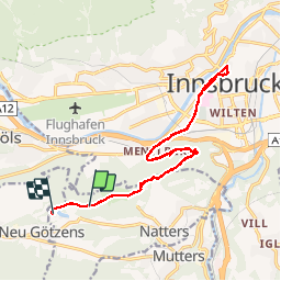
8,9 km | 12,8 km-effort
2h 54min
Oui
Randonnée A pied Inconnu - Rauschbrunnen-Runde - Photo
A pied
PRO

A pied

Facile
Inconnu, Tyrol, Innsbruck, Autriche
7,9 km | 13,7 km-effort
3h 6min
Oui
Randonnée A pied Inconnu - Rundwanderweg Rosengarten - Photo
A pied
PRO

A pied

Facile
Inconnu, Tyrol, Innsbruck, Autriche
4,9 km | 6,6 km-effort
1h 29min
Oui
Randonnée A pied  - Lanser-Kopf-Lauf - Photo
A pied
PRO

A pied

Facile
, Tyrol, Innsbruck, Autriche
10,3 km | 14,6 km-effort
3h 19min
Oui
Randonnée V.T.C. Gemeinde Natters - natterer  - Photo
V.T.C.
Maca8284

V.T.C.

Très facile
Gemeinde Natters, Tyrol, Bezirk Innsbruck-Land, Autriche
17,3 km | 24 km-effort
2h 0min
Oui
Randonnée Marche nordique Gemeinde Natters - autour natterer see - Photo
Marche nordique
Maca8284

Marche nordique

Très facile
Gemeinde Natters, Tyrol, Bezirk Innsbruck-Land, Autriche
10,5 km | 14,9 km-effort
2h 54min
Oui
Randonnée Marche Gemeinde Natters - Innsbruck natterer see  - Photo
Marche
Maca8284

Marche

Très facile
Gemeinde Natters, Tyrol, Bezirk Innsbruck-Land, Autriche
19,9 km | 27 km-effort
5h 13min
Oui
Randonnée Marche Gemeinde Götzens - Nattersee Camping Hofhockweg AR - Photo
Marche
Maca8284

Marche

Moyen
Gemeinde Götzens, Tyrol, Bezirk Innsbruck-Land, Autriche
13,8 km | 22 km-effort
4h 14min
Oui
Randonnée Marche Gemeinde Natters - Nattersee Camping - Nockhofweg - Batters AR - Photo
Marche
Maca8284

Marche

Difficile
Gemeinde Natters, Tyrol, Bezirk Innsbruck-Land, Autriche
13,3 km | 20 km-effort
3h 42min
Oui


Fermer
Mes abonnements